


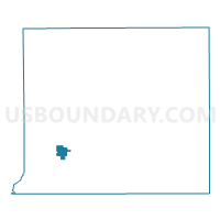
Voting District 1491786000002, St. Joseph County, Michigan
About
Outline

Summary
| Unique Area Identifier | 599507 |
| Name | Voting District 1491786000002 |
| County | St. Joseph County |
| State | Michigan |
| Area (square miles) | 1.72 |
| Land Area (square miles) | 1.56 |
| Water Area (square miles) | 0.16 |
| % of Land Area | 90.60 |
| % of Water Area | 9.40 |
| Latitude of the Internal Point | 41.83795550 |
| Longtitude of the Internal Point | -85.66521220 |
Maps

Graphs
Select a template below for downloading or customizing gragh for Voting District 1491786000002, St. Joseph County, Michigan


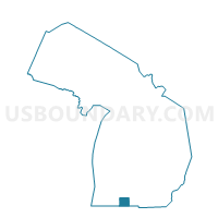
Neighbors
Neighoring Voting District (by Name) Neighboring Voting District on the Map
- Voting District 1491786000001, St. Joseph County, MI
- Voting District 1492906000001, St. Joseph County, MI
Top 10 Neighboring County Subdivision (by Population) Neighboring County Subdivision on the Map
- Constantine township, St. Joseph County, MI (4,217)
- Florence township, St. Joseph County, MI (1,242)